BC Data Catalogue Resources

  Audience  
Catalogue Editors Catalogue Admin Catalogue Developers

Resources

3.11 Core Administrative and Descriptive Metadata Standards and Guidelines

  • This document is being updated to reflect the alignment with this core standard.

Table of Fields in Data Catalogue align with Metadata Standard and Guidelines

To align with the new Metadata Standard and Guidelines, the following table outline how fields in B.C. Data Catalogue aligns with Metadata Standard and Guidelines.

Elements in Metadata Standard and Guidelines Fileds in B.C. Data Catalogue
CREATOR Published by
DATE CREATED Lifecycle event -> Created
DATE MODIFIED Lifecycle event -> Modified
DESCRIPTION Description, Purpose, Quality, Lineage, Resource Description, Resource Supplemental Information
FILE FORMAT Resource Storage Format
SECURITY CLASSIFICATION Security Classification
TITLE Title and Resource Title
UNIQUE IDENTIFIER Each Record and Resource has a unique identifier. There are obtained by using the Share button
INFORMATION SCHEDULE This is managed at different levels for organizations, request an engagement with us to determine where it best fits.
  If you have general questions about the catalogue or wish to provide feedback, please open a ticket with the Data Systems & Services request system

Table of Contents

Resource types

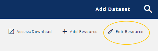
There are four types of Resources using in the BC Data Catalogue.

Application

A type of resource associated to a record, which is used for applications that provide access to data.

Document and Tabular Data

A type of resource associated to a record, which is used for tables in Comma Separated Value (CSV) files, or MS Excel Spreadsheets (XLS) or possibly even tabular PDF files.

Geographic Data

A resource type associated to a record, which is used for data that may, or may not, contains geospatial information along with other data.  Additional geospatial metadata elements are available to be populated, e.g., spatial reference system. This resource type must be used for all BCGW resources.

Web Service and API

A resource type associated to a record, which is used for metadata relating to web services or application programming interfaces (APIs).

Side Notes:

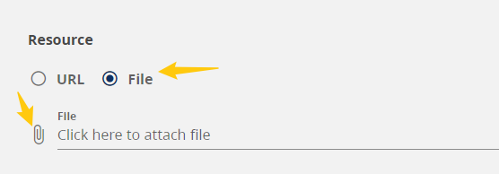
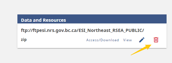
  1. Resources may reside, depending on type and size within the Catalogue database itself (Data Store) or be externally referenced.
  2. Resources which are sourced from the BC Geographic Warehouse (BCGW) are managed differently.
  3. Resources may be only metadata about a resource that is not accessible or requires authorization to access.
    • If a resource requires authorization, we recommend that that process or form is linked as a resource to the record, e.g. Request Archaeology Information.

RETURN TO TOP

Resource management

Add a Resource

image

To add a resource:

  1. Click the Add Resource button on the toolbar at the record level.
  2. Fill out all the required fields for each resource type as described below as noted in the field section.
  • Only files less than 150MB in size can be uploaded to the Catalogue file store.

RETURN TO TOP

Edit a Resource

To edit a resource:

  1. Log In
  2. Navigate to the record to edit (that you have the privileges to do so) and either:
    1. Click the Pencil icon on the Resource Card list on the right or
      • This will open the resource in edit mode.

      image

    2. Click on the resource title or the View button. And click on the Edit Resource button. image
  3. Update the file(s) as needed. See the field section for more details.

RETURN TO TOP

Replace a file in the catalogue Data Store

  • Requirement:
    • Zipped folders can be uploaded but do not upload a file from within an already zipped folder.
  1. Once in edit mode of the resource image
  2. Click on the File circle and then the paper clip icon image
  3. Navigate to new replacement file
  4. Click Open
  5. Click Save

image

RETURN TO TOP

Delete a Resource

Editors can delete resources in any published state

To delete a resource:

  1. Log In
  2. Navigate to the record to edit (that you have the privileges to do so) and either:
    1. Click the trashcan icon on the Resource Card list on the right and confirm, or image
    2. Click on the resource title or the View button.
      1. Click on the Delete Resource button and confirm. image

RETURN TO TOP


Resource fields

* indicates required fields.

Name * (name)

  • Is the name or title of the resource as it will appear on the resource record and card.
  • A well defined title reflects what the resource is about and what the user will expect by accessing the resource. This is done by using actionable language, e.g., Download, Export, View, Explore and then details of what the resource is.
Type: Application Tabular/ Docment Geographic Web Service/ API
Available Field Y Y Y Y

Resource (url)

  • Is a link to a file or resource stored elsewhere.
Type: Application Tabular/ Docment Geographic Web Service/ API
Available Field Y Y Y Y

Type * (bcdc_type)

  • Is the resource type that defines the available fields for a resource.
Type: Application Tabular/ Docment Geographic Web Service/ API
Available Field Y Y Y Y
Select: ‘Application’ (application) ‘Tabular’ (dataset) ‘Geographic Dataset’ (geographic) ‘Web Service/API’ (webservice)

Resource description (description)

  • Is a detailed description of the resource.

Core Administrative and Descriptive Metadata Guidelines

  • This field aligns with the standard field DESCRIPTION.
  • Refer to both the standard and guideline.
Type: Application Tabular/ Docment Geographic Web Service/ API
Available Field Y Y Y Y

Supplemental information (supplemental_info)

  • Any additional relevant information about the resource can be included here.

Core Administrative and Descriptive Metadata Guidelines

  • This field aligns with the standard field DESCRIPTION.
  • Refer to both the standard and guideline.
Type: Application Tabular/ Docment Geographic Web Service/ API
Available Field Y Y Y Y

Frequency of resource update * (resource_update_cycle)

  • Describes how often the resource is updated.
Type: Application Tabular/ Docment Geographic Web Service/ API
Available Field Y Y Y Y

Resource data last updated * (last_modified)

  • Describes how often the resource is updated.
  • This is only visible in view mode for datasets:
    • Uploaded to the catalogue itself
    • Published to the BC Geographic Warehouse
      • An automated system pushes the reloaded timestamp
  • If interested in setting up your own automated processes to update via the API, contact us at the Data Systems and Services Request System and ask for more information on how to enhance to your offerings in the Catalogue.
    • Endpoint required parameters:
      • id (resource id)
      • timestamp (format: 2022-02-27 10:00:01)

Core Administrative and Descriptive Metadata Guidelines

  • This field aligns with the standard field MODIFIED.
  • Refer to both the standard and guideline.

Data collection period (temporal_extent)

  • A Start and/or End Data can be added if the data reflects a period of time.’.
Type: Application Tabular/ Docment Geographic Web Service/ API
Available Field Y Y Y Y
  • Beginning date (beginning_date)
    • The start date for the period the data is captured for
  • End date (end_date):
    • The end date for the period the data is captured for.

Resource storage format * (format)

  • Describes the file extension for the resource

Core Administrative and Descriptive Metadata Guidelines

  • This field aligns with the standard field FILE FORMAT.
  • Refer to both the standard and guideline.
Type: Application Tabular/ Docment Geographic Web Service/ API
Available Field Y Y Y Y

Resource storage location * (resource_storage_location)

  • The location the data is stored in
Type: Application Tabular/ Docment Geographic Web Service/ API
Available Field Y Y Y Y

Spatial datatype * (spatial_datatype)

  • The datatype in a database.
Type: Application Tabular/ Docment Geographic Web Service/ API
Available Field Y Y Y Y

Object name (object_name)

  • Is the name of the dataset stored in a database.
Type: Application Tabular/ Docment Geographic Web Service/ API
Available Field N N Y N

Object short name (object_short_name)

  • For BCGW datasets, the short name used for download for Shape Files.
  • This is a non-editable field and only show when the Resource storage location is set to ‘BC Geographic Warehouse’
  • This is populated via an automated process pushed from the BCGW to the Catalogue.

Object table comments (object_table_comments)

  • For BCGW datasets, the data definition in a database.
  • This is a non-editable field and only show when the Resource storage location is set to ‘BC Geographic Warehouse’
  • This is populated via an automated process pushed from the BCGW to the Catalogue.

Details: (details) Section

  • For BCGW datasets, this is populated from the database metadata.
  • This is a non-editable field and only show when the Resource storage location is set to ‘BC Geographic Warehouse’
  • This is populated via an automated process pushed from the BCGW to the Catalogue.
    • Column name (column_name): Name of the column in a database.
    • Short name (short_name): Short name used for download for Shape Files and CSV.
    • Data type (data_type): Field type
    • Data precision (data_precision): Field length
    • Column comments (column_comments): Field definition

Projection name * (projection_name)

  • Is a drop down list of common projections used in BC for geographic data.
Type: Application Tabular/ Docment Geographic Web Service/ API
Available Field N N Y YNEW

JSON Table Schema (json_table_schema)

+

Type: Application Tabular/ Docment Geographic Web Service/ API
Available Field Y Y Y Y

ISO Topic Category * (iso_topic_category)

Type: Application Tabular/ Docment Geographic Web Service/ API
Available Field N N Y N

Resource type (resource_type)

  • Is the type of resource.
  • Being reviewed if useful.
Type: Application Tabular/ Docment Geographic Web Service/ API
Available Field Y Y Y Y

Resource access method * (resource_access_method)

  • Describes how the end-user can access the data.
  • Being reviewed if useful.
Type: Application Tabular/ Docment Geographic Web Service/ API
Available Field Y Y Y Y

Preview information (preview_info) Section

  • Automatically populated if public to build the Map Preview.
Type: Application Tabular/ Docment Geographic Web Service/ API
Available Field N N Y N
  • Layer name (layer_name): is the name of the BCGW object and is only different if the WMS uses a generalized dataset.
  • Preview latitude (preview_latitude): allows you to provide a map preview centroid latitude.
  • Preview longitude (preview_longitude): allows you to provide a map preview centroid longitude.
  • Preview map aervice URL (preview_map_service_url): allows you to provide an alias for the map service URL.
  • Preview zoom level (preview_zoom_level): allows you to provide an initial zoom level for the map preview.
  • Image URL (preview_image_url): shows a preview of the data as a static image.
  • Link to iMapBC (link_to_imap): shows an interactive preview of the data in iMapBC.

Geographic extent (geographic_extent) Section

  • These are auto populated with the bounding box of the province.
Type: Application Tabular/ Docment Geographic Web Service/ API
Available Field N N Y N
  • North (north_bound_latitude): 60.0
  • South (south_bound_latitude): 48.0
  • East (east_bound_longitude): -113.5
  • West (west_bound_longitude):-139.5

Click Save when done

  • Additional resources can be added by repeating the process above or adding other resource types.

RETURN TO TOP


DataBC Services naming and describing guidelines - DRAFT

This section is currently being developed.

BC Geographic Warehouse

  • BC Geographic Warehouse is a selection available in the Resource Storage Location.
  • Certain resources will be generated on your behalf, including:
    • Exportable or not
      • This is created when working with the Data Publication Services team.
    • WMS
      • This is generated the week after publication to iMapBC.
      • However, the script to automate the creation of these catalogue references is being redeveloped.
      • See Getting started for links to our request system
    • Network Link KML
      • This is generated the week after publication to iMapBC.
      • However, the script to automate the creation of these catalogue references is being redeveloped.
  • Certain resources are in review for automatic generation, including:
    • ArcGIS Online if hosted or served out through DataBC
    • WFS
    • iMapBC
  • Certain fields will be populated on your behalf, including:
    • Preview Details - includes map visible in the Preview popup and iMapBC link
    • Object Details

Exportable or Not Resources

Catalogue Fields Exportable Not Exportable
Title View or Export BC Geographic Warehouse details (custom download) View BC Geographic Warehouse details (export not enabled)
URL Leave blank Leave blank
Resource type Geographic Geographic
Resource description The Distribution Service allows for data to be exportable in various file formats from the B.C. Geographic Warehouse (BCGW), a central government repository of spatial and non-spatial data. The Distribution Service has not been enabled for export this data from the B.C. Geographic Warehouse (BCGW), a central government repository of spatial and non-spatial data.
Supplemenental info See the main dataset page for more information. The Distribution Service has been disabled for the data from the B.C. Geographic Warehouse (BCGW), a central government repository of spatial and non-spatial data.
Supplemenental info Click Access/Download in the toolbar to download this dataset. For more information on using the distribution order form see How to download data using the Catalogue or iMapBC. See the main dataset page for more information.
Resource storage format multiple Oracle/SDE
Resource storage location BC Geographic Warehouse BC Geographic Warehouse
Spatial datatype SDO Geometry SDO Geometry
Object name SCHEMA.TABLE SCHEMA.TABLE
Projection name EPSG_3005 - NAD83 BC Albers EPSG_3005 - NAD83 BC Albers
Resource access method Indirect Indirect

Specific Field Requirements to Enable Export

  • To enable the Download/Access button to pop-up the Persistent Order Widget (POW) the following must be populated:
    1. Name: Must contain “Custom Download”
      • Suggestions are in the above table for best titles if downloadable or not
    2. Resource Storage Location: “BC Geographic Warehouse”
    3. Object name: e.g., “WHSE_ADMIN_BOUNDARIES.ADM_NR_DISTRICTS_SP”
  • Object name
    • Is the name of the dataset stored in a database.
    • Enter the SCHEMA.OBJECT , e.g., WHSE_ADMIN_BOUNDARIES.ADM_NR_DISTRICTS_SP
    • The object name is what is used to automatically populate the metadata record with
      • The data definitions table that is extracted from the Oracle metadata.
      • For public datasets that are available in iMapBC:
        • The WMS getCapabilities request resources
        • The Network Link KML resources
        • The Preview Map details
        • The View in iMapBC button will that dataset’s specific presentations
    • Always check to make sure there is no space at the end of the value.

Retired or Replaced Resources

Catalogue Fields Retired Replaced
Title View Retired BC Geographic Warehouse details (export disabled) View Replaced BC Geographic Warehouse details (export disabled)
URL Leave blank Leave blank
Type Geographic Geographic
Resource Description    
Supplemenental Info See the main dataset page for more information. See the main dataset page for more information.
Resource Storage Format multiple Oracle/SDE
Resource Storage Location BC Geographic Warehouse BC Geographic Warehouse
Spatial Datatype SDO Geometry SDO Geometry
Object Name SCHEMA.TABLE SCHEMA.TABLE
Projection EPSG_3005 - NAD83 BC Albers EPSG_3005 - NAD83 BC Albers
Resource Access Method Indirect Indirect

Generalized Resources

Generalized resources are now to be included as an additional resource on the non-generalized record.

Catalogue Fields Text Examples
Title View BC Geographic Warehouse details (export is not enabled)
Resource description The Distribution Service has not been enabled to allow for data to be downloaded in various file formats from the B.C. Geographic Warehouse (BCGW), a central government repository of spatial and non-spatial data. See the main page for additional information.
Resource storage format Oracle/SDE

Web Mapping Resources

Catalogue Fields WMS WFS Network Link KML iMapBC
Title View WMS getCapabilities request details View WFS getCapabilities request details View Retired BC Geographic Warehouse details (export disabled) View Replaced BC Geographic Warehouse details (export disabled)
URL Leave blank for all of these      
Type Web Service/API      
Resource description Web Mapping Service (WMS) allows for data to be fed out via a service from the B.C. Geographic Warehouse (BCGW), a central government repository of spatial and non-spatial data.      
Supplemenental info Click Access/Download in the toolbar to see or copy the WMS call. For more information see Web Mapping Services.      
Resource storage format wms wfs kml html or geojson
Resource storage location BC Geographic Warehouse      
Spatial datatype SDO Geometry      
Object name SCHEMA.TABLE      
Projection name ESPG_4326 - WSG84 World Geodedic System 1984 ESPG_4326 - WSG84 World Geodedic System 1984 ESPG_4326 - WSG84 World Geodedic System 1984  
Resource access method Service Service Service Application

ArcGIS Online (AGO) Resources

Catalogue Fields Data Web Maps Web Apps Tile Services
Title Data - Open item details ArcGIS Online (AGO) Web map - Open item details ArcGIS Online (AGO) Web app - Open item details ArcGIS Online (AGO) Tile service - Open item details ArcGIS Online (AGO)
URL Leave blank for all of these      
Type Geographic Application Application Service
Resource description The Distribution Service allows for data to be downloaded in various file formats from the B.C. Geographic Warehouse (BCGW), a central government repository of spatial and non-spatial data.      
Supplemenental info Click Access/Download in the toolbar to download this dataset. For more information on using the distribution order form see How to download data using the Catalogue or iMapBC.      
Resource storage format ArcGIS Rest other other other
Resource storage location BC Geographic Warehouse or ESRI ARcGIS Online if hosted      
Spatial datatype SDO Geometry      
Object name SCHEMA.TABLE      
Projection name EPSG_3005 - NAD83 BC Albers or hosted is ESPG_3857 Not Applicable Not Applicable  
Resource access method Direct Application Application Direct

BC Data Catalogue Hosted Resources

RETURN TO TOP


Additional resources

  • See the full list of value options for drop down fields, see the BCDC Schema
  • See all documented changes in the Change Log

RETURN TO TOP