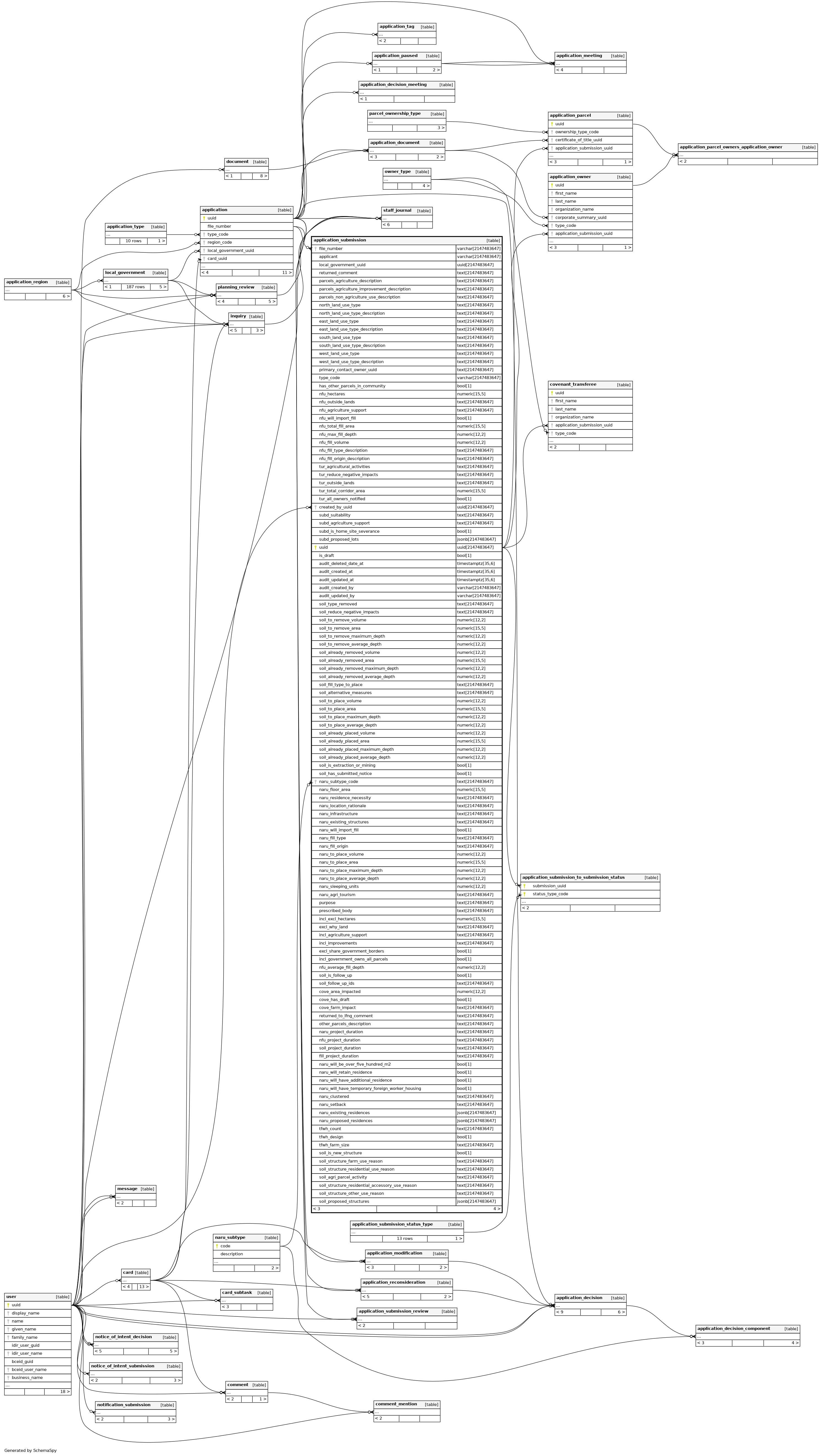
Columns
| Column | Type | Size | Nulls | Auto | Default | Children | Parents | Comments | ||||||||||||
|---|---|---|---|---|---|---|---|---|---|---|---|---|---|---|---|---|---|---|---|---|
| file_number | varchar | 2147483647 | null |
|
|
File Number of attached application |
||||||||||||||
| applicant | varchar | 2147483647 | √ | null |
|
|
The Applicants name on the application |
|||||||||||||
| local_government_uuid | uuid | 2147483647 | √ | null |
|
|
UUID from ALCS System of the Local Government |
|||||||||||||
| returned_comment | text | 2147483647 | √ | null |
|
|
Used to store comments when an Application is returned to the Applicant |
|||||||||||||
| parcels_agriculture_description | text | 2147483647 | √ | null |
|
|
Describe all agriculture that currently takes place on the parcel(s). |
|||||||||||||
| parcels_agriculture_improvement_description | text | 2147483647 | √ | null |
|
|
Describe all agricultural improvements made to the parcel(s). |
|||||||||||||
| parcels_non_agriculture_use_description | text | 2147483647 | √ | null |
|
|
Describe all other uses that currently take place on the parcel(s). |
|||||||||||||
| north_land_use_type | text | 2147483647 | √ | null |
|
|
The land uses surrounding the parcel(s) under application on the North. |
|||||||||||||
| north_land_use_type_description | text | 2147483647 | √ | null |
|
|
Description of the land uses surrounding the parcel(s) under application on the North. |
|||||||||||||
| east_land_use_type | text | 2147483647 | √ | null |
|
|
The land uses surrounding the parcel(s) under application on the East. |
|||||||||||||
| east_land_use_type_description | text | 2147483647 | √ | null |
|
|
Description of the land uses surrounding the parcel(s) under application on the East. |
|||||||||||||
| south_land_use_type | text | 2147483647 | √ | null |
|
|
The land uses surrounding the parcel(s) under application on the South. |
|||||||||||||
| south_land_use_type_description | text | 2147483647 | √ | null |
|
|
Description of the land uses surrounding the parcel(s) under application on the South. |
|||||||||||||
| west_land_use_type | text | 2147483647 | √ | null |
|
|
The land uses surrounding the parcel(s) under application on the West. |
|||||||||||||
| west_land_use_type_description | text | 2147483647 | √ | null |
|
|
Description of the land uses surrounding the parcel(s) under application on the West. |
|||||||||||||
| primary_contact_owner_uuid | text | 2147483647 | √ | null |
|
|
Stores Uuid of Owner Selected as Primary Contact |
|||||||||||||
| type_code | varchar | 2147483647 | null |
|
|
Application Type Code from ALCS System |
||||||||||||||
| has_other_parcels_in_community | bool | 1 | √ | null |
|
|
Indicates whether application owners have other parcels in the community. |
|||||||||||||
| nfu_hectares | numeric | 15,5 | √ | null |
|
|
||||||||||||||
| nfu_outside_lands | text | 2147483647 | √ | null |
|
|
||||||||||||||
| nfu_agriculture_support | text | 2147483647 | √ | null |
|
|
||||||||||||||
| nfu_will_import_fill | bool | 1 | √ | null |
|
|
||||||||||||||
| nfu_total_fill_area | numeric | 15,5 | √ | null |
|
|
||||||||||||||
| nfu_max_fill_depth | numeric | 12,2 | √ | null |
|
|
||||||||||||||
| nfu_fill_volume | numeric | 12,2 | √ | null |
|
|
||||||||||||||
| nfu_fill_type_description | text | 2147483647 | √ | null |
|
|
||||||||||||||
| nfu_fill_origin_description | text | 2147483647 | √ | null |
|
|
||||||||||||||
| tur_agricultural_activities | text | 2147483647 | √ | null |
|
|
||||||||||||||
| tur_reduce_negative_impacts | text | 2147483647 | √ | null |
|
|
||||||||||||||
| tur_outside_lands | text | 2147483647 | √ | null |
|
|
||||||||||||||
| tur_total_corridor_area | numeric | 15,5 | √ | null |
|
|
||||||||||||||
| tur_all_owners_notified | bool | 1 | √ | null |
|
|
||||||||||||||
| created_by_uuid | uuid | 2147483647 | √ | null |
|
|
||||||||||||||
| subd_suitability | text | 2147483647 | √ | null |
|
|
||||||||||||||
| subd_agriculture_support | text | 2147483647 | √ | null |
|
|
||||||||||||||
| subd_is_home_site_severance | bool | 1 | √ | null |
|
|
||||||||||||||
| subd_proposed_lots | jsonb | 2147483647 | '[]'::jsonb |
|
|
JSONB Column containing the proposed subdivision lots |
||||||||||||||
| uuid | uuid | 2147483647 | gen_random_uuid() |
|
|
|||||||||||||||
| is_draft | bool | 1 | false |
|
|
Indicates whether submission is currently draft or not |
||||||||||||||
| audit_deleted_date_at | timestamptz | 35,6 | √ | null |
|
|
||||||||||||||
| audit_created_at | timestamptz | 35,6 | now() |
|
|
|||||||||||||||
| audit_updated_at | timestamptz | 35,6 | √ | now() |
|
|
||||||||||||||
| audit_created_by | varchar | 2147483647 | null |
|
|
|||||||||||||||
| audit_updated_by | varchar | 2147483647 | √ | null |
|
|
||||||||||||||
| soil_type_removed | text | 2147483647 | √ | null |
|
|
||||||||||||||
| soil_reduce_negative_impacts | text | 2147483647 | √ | null |
|
|
||||||||||||||
| soil_to_remove_volume | numeric | 12,2 | √ | null |
|
|
||||||||||||||
| soil_to_remove_area | numeric | 15,5 | √ | null |
|
|
||||||||||||||
| soil_to_remove_maximum_depth | numeric | 12,2 | √ | null |
|
|
||||||||||||||
| soil_to_remove_average_depth | numeric | 12,2 | √ | null |
|
|
||||||||||||||
| soil_already_removed_volume | numeric | 12,2 | √ | null |
|
|
||||||||||||||
| soil_already_removed_area | numeric | 15,5 | √ | null |
|
|
||||||||||||||
| soil_already_removed_maximum_depth | numeric | 12,2 | √ | null |
|
|
||||||||||||||
| soil_already_removed_average_depth | numeric | 12,2 | √ | null |
|
|
||||||||||||||
| soil_fill_type_to_place | text | 2147483647 | √ | null |
|
|
||||||||||||||
| soil_alternative_measures | text | 2147483647 | √ | null |
|
|
||||||||||||||
| soil_to_place_volume | numeric | 12,2 | √ | null |
|
|
||||||||||||||
| soil_to_place_area | numeric | 15,5 | √ | null |
|
|
||||||||||||||
| soil_to_place_maximum_depth | numeric | 12,2 | √ | null |
|
|
||||||||||||||
| soil_to_place_average_depth | numeric | 12,2 | √ | null |
|
|
||||||||||||||
| soil_already_placed_volume | numeric | 12,2 | √ | null |
|
|
||||||||||||||
| soil_already_placed_area | numeric | 15,5 | √ | null |
|
|
||||||||||||||
| soil_already_placed_maximum_depth | numeric | 12,2 | √ | null |
|
|
||||||||||||||
| soil_already_placed_average_depth | numeric | 12,2 | √ | null |
|
|
||||||||||||||
| soil_is_extraction_or_mining | bool | 1 | √ | null |
|
|
||||||||||||||
| soil_has_submitted_notice | bool | 1 | √ | null |
|
|
||||||||||||||
| naru_subtype_code | text | 2147483647 | √ | null |
|
|
||||||||||||||
| naru_floor_area | numeric | 15,5 | √ | null |
|
|
||||||||||||||
| naru_residence_necessity | text | 2147483647 | √ | null |
|
|
||||||||||||||
| naru_location_rationale | text | 2147483647 | √ | null |
|
|
||||||||||||||
| naru_infrastructure | text | 2147483647 | √ | null |
|
|
||||||||||||||
| naru_existing_structures | text | 2147483647 | √ | null |
|
|
||||||||||||||
| naru_will_import_fill | bool | 1 | √ | null |
|
|
||||||||||||||
| naru_fill_type | text | 2147483647 | √ | null |
|
|
||||||||||||||
| naru_fill_origin | text | 2147483647 | √ | null |
|
|
||||||||||||||
| naru_to_place_volume | numeric | 12,2 | √ | null |
|
|
||||||||||||||
| naru_to_place_area | numeric | 15,5 | √ | null |
|
|
||||||||||||||
| naru_to_place_maximum_depth | numeric | 12,2 | √ | null |
|
|
||||||||||||||
| naru_to_place_average_depth | numeric | 12,2 | √ | null |
|
|
||||||||||||||
| naru_sleeping_units | numeric | 12,2 | √ | null |
|
|
||||||||||||||
| naru_agri_tourism | text | 2147483647 | √ | null |
|
|
||||||||||||||
| purpose | text | 2147483647 | √ | null |
|
|
||||||||||||||
| prescribed_body | text | 2147483647 | √ | null |
|
|
||||||||||||||
| incl_excl_hectares | numeric | 15,5 | √ | null |
|
|
||||||||||||||
| excl_why_land | text | 2147483647 | √ | null |
|
|
||||||||||||||
| incl_agriculture_support | text | 2147483647 | √ | null |
|
|
||||||||||||||
| incl_improvements | text | 2147483647 | √ | null |
|
|
||||||||||||||
| bool | 1 | √ | null |
|
|
|||||||||||||||
| incl_government_owns_all_parcels | bool | 1 | √ | null |
|
|
||||||||||||||
| nfu_average_fill_depth | numeric | 12,2 | √ | null |
|
|
||||||||||||||
| soil_is_follow_up | bool | 1 | √ | null |
|
|
||||||||||||||
| soil_follow_up_ids | text | 2147483647 | √ | null |
|
|
||||||||||||||
| cove_area_impacted | numeric | 12,2 | √ | null |
|
|
||||||||||||||
| cove_has_draft | bool | 1 | √ | null |
|
|
||||||||||||||
| cove_farm_impact | text | 2147483647 | √ | null |
|
|
||||||||||||||
| returned_to_lfng_comment | text | 2147483647 | √ | null |
|
|
Used to store comments when an Application is returned to the L/FNG by ALC Staff |
|||||||||||||
| other_parcels_description | text | 2147483647 | √ | null |
|
|
Stores the data user entered about other parcels in their community |
|||||||||||||
| naru_project_duration | text | 2147483647 | √ | null |
|
|
||||||||||||||
| nfu_project_duration | text | 2147483647 | √ | null |
|
|
||||||||||||||
| soil_project_duration | text | 2147483647 | √ | null |
|
|
||||||||||||||
| fill_project_duration | text | 2147483647 | √ | null |
|
|
||||||||||||||
| naru_will_be_over_five_hundred_m2 | bool | 1 | √ | null |
|
|
||||||||||||||
| naru_will_retain_residence | bool | 1 | √ | null |
|
|
||||||||||||||
| naru_will_have_additional_residence | bool | 1 | √ | null |
|
|
||||||||||||||
| naru_will_have_temporary_foreign_worker_housing | bool | 1 | √ | null |
|
|
||||||||||||||
| naru_clustered | text | 2147483647 | √ | null |
|
|
||||||||||||||
| naru_setback | text | 2147483647 | √ | null |
|
|
||||||||||||||
| naru_existing_residences | jsonb | 2147483647 | '[]'::jsonb |
|
|
JSONB column containing NARU existing residences |
||||||||||||||
| naru_proposed_residences | jsonb | 2147483647 | '[]'::jsonb |
|
|
JSONB column containing NARU proposed residences |
||||||||||||||
| tfwh_count | text | 2147483647 | √ | null |
|
|
||||||||||||||
| tfwh_design | bool | 1 | √ | null |
|
|
||||||||||||||
| tfwh_farm_size | text | 2147483647 | √ | null |
|
|
||||||||||||||
| soil_is_new_structure | bool | 1 | √ | null |
|
|
||||||||||||||
| soil_structure_farm_use_reason | text | 2147483647 | √ | null |
|
|
||||||||||||||
| soil_structure_residential_use_reason | text | 2147483647 | √ | null |
|
|
||||||||||||||
| soil_agri_parcel_activity | text | 2147483647 | √ | null |
|
|
||||||||||||||
| soil_structure_residential_accessory_use_reason | text | 2147483647 | √ | null |
|
|
||||||||||||||
| soil_structure_other_use_reason | text | 2147483647 | √ | null |
|
|
||||||||||||||
| soil_proposed_structures | jsonb | 2147483647 | '[]'::jsonb |
|
|
JSONB Column containing the proposed structures |
Indexes
| Constraint Name | Type | Sort | Column(s) |
|---|---|---|---|
| PK_61e192975e82347bab189b34fcc | Primary key | Asc | uuid |
| IDX_4776c7dcd306a47a372b322fd9 | Performance | Asc | file_number |
Relationships
Close relationships within degrees of separation